 |
| View of town from nearby hill |
More than 1,000 kilometres east of Broome is the town of Kununarra, thirty seven kilometres from the Northern Territory border. When flying over the Kimberley the landscape below - red earth with occasional sage green foliage - could be imagined as a Fred Williams painting.
Kununurra was built in the 1960s as a township to service the Ord River irrigation scheme. The town is on the banks of Lake Kununurra. The first stage of the Ord River Scheme was completed in 1963 and the second stage completed nine years later with the opening of Lake Argyle Dam.
 |
| View looking towards irrigation area |
The Ord River irrigation scheme has resulted in 14,000 hectares of land now available for farming. Crops grown include chickpeas, sorghum seed, melons, pumpkins, mangoes, bananas, citrus, irrigated pasture, tropical forests and sugar cane.
 |
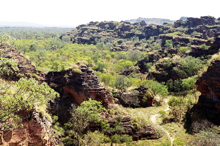
| Mirima National Park |
Two kilometres from the town is the Mirima National Park providing an example of the original landscape in the area. The rock formations are similar to those found in the Bungle Bungles.
The lakes are a major feature of the area. We spent an afternoon exploring part of the Lake Kununarra and Lake Argyle water system. Lake Argyle is nine times the size of Sydney Harbour. The permanent supply of water all year round due to the creation of the lakes as part of the irrigation system has created new industries in a region surrounded by desert.
 |
| Flying foxes |
|
 |
| Crocodile
|
|
 |
| Rock wallabies |
There was plenty of wildlife to be seen from the boat. |


No comments:
Post a Comment